Using the Nix Pro for Soil Color Sensor Data
A group of students and staff members at Clemson University have created a study using accurate, and low-cost sensor technology to collect soil color data. The objective of this study was to develop a mobile application that would enable users to create their own soils database consisting of GPS location and soil color data gathered using the application with the Nix Pro. The content below will discuss background knowledge on this study, and show how the Nix Pro Color Sensor has been used to benefit the research and development of this mobile application. All original data and further details from this study can be read, and found at: Geoderma.
![]()
Soil color is an important property used by the USDA Natural Resorces Conservation Service(NRCS) to describe soils and indicate other soil properties, such as iron and organic matter contents. The Munsell Soil Color Chart (MSCC) notation is commonly used to describe soil color; however, studies have shown that there are inconsistencies in the printing quality of MSCC color chips as well as a strong potential for fading. This makes the charts unreliable, yet the MSCC has been the standard in-field method of soil color determination for decades. On the other hand, instruments such as spectrophotometers and colorimeters are often used as an alternative method to color analysis but are very expensive, and may require external power sources. As a result, this makes in-field color determination very difficult.
The development of technology and mobile devices offer the opportunity to quickly and easily analyze certain soil properties. The university expressed that current mobile applications commonly face limitations based on the device and environmental conditions, and expressed that the application and device should be user-friendly as well as inexpensive. Therefore, the objective of this study was to develop an Android-based application that was capable of working with the Nix Pro Color Sensor to produce:
- CYAN, Magenta, yellow and black (CMYK)
- XYZ
- RGB
- CIELab
- MSCC color values
- Record GPS locations
- Upload collected data to a constantly updating Cloud databank
In a different study, a cellphone application was created to determine the color of soil samples from pictures taken with the camera of a cell phone. The software was developed to scan the pixels in the soil sample pictures and convert the subsequent red, green and blue (RBG) color values to digital red, green and blue (XYZ), and to Munsell hue, value, chroma (HVC). By using this method, they were able to accurately classify soils; however, it was noted that differences in cellphone hardware may result in a change of accuracy in results and software stability. In addition to this, environmental factors such as the moisture of soil and lighting conditions would still affect the study results.
As a result, multiple soil samples were analyzed for color in moist and dry soil conditions, as well as indoor and outdoor lighting. The Nix Pro’s patented shape blocks out all ambient lighting and provides its own calibrated light source for accurate results. The device’s color values of the Nix Pro were compared to MSCC as well as a Konica Minolta CR-400 laboratory colorimeter. The results showed that the Nix Pro produced repeatable readings, and the color values of the Nix Pro and Konica Minolta were very similar. Roxanne Stiglitz concluded that the Nix Pro would be a good alternative to the MSCC as an in-field soil color determination method.
Developing the Color Application
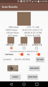
The Soil Scanner mobile app was completed using Google’s integrated development environment (IDE) software, Android Studio 2.0, to compile and edit the code for the App. Nix Sensor Ltd. provided access to the Nix Pro’s application program interface (API). Upon completion, the application was able to connect to a Nix Pro Color Sensor, download a Munsell color reference table, and scan soil samples for its color. The resulting color systems include CMYK, CIELab, XYZ, RGB, and Munsell notations.
Users have the ability to choose whether the samples are analyzed in a “field setting” and if the soil samples are dry or moist.
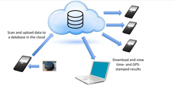
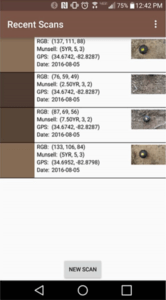
Field Setting – enables the user to obtain the GPS location of the sample. The user also has the option to take a reference photo of soil samples using the mobile device’s camera to be saved with all other collected data (Fig.3). Recently scanned data can be recalled within the App and the user has the option of uploading all data to an online database for safe storage (Fig.4).
Testing the Color Application & Results
After the development of the Soil Scanner app was completed, the functionality and accuracy of the Munsell color results were tested. The university used a Samsung Galaxy S6 Edge, Android version 5.1.1, with a camera resolution of 16 megapixels. Thirty-one oven-dried, crumpled soil samples were collected at varying depths from 13 soil pits, were analyzed for Munsell color using the Nix Pro Color Sensor.
By utilizing the Nix Pro, this study is conducted with a standardized light source and sensing hardware, which controls for light and sensor differences rather than relying on other methods, such as pixels in a photo taken by a smartphone. The study has shown that using an application and sensor also increases the speed of soil color sampling. A larger number of samples is now possible, which provides enough data for statistical comparisons for a variety of soil colors and properties. The scanned data can then be uploaded to cloud storage, can be downloaded, and plotted in GIS for visualization and analysis. The Soil Scanner data can be analyzed in this way for multiple soil components that could assist in generating soil erosion, fertility, and moisture maps using GIS software.
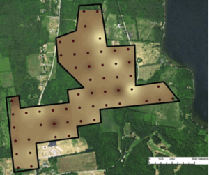
The Soil Scanner application for gathering soil color and GPS data with the Nix Pro Color Sensor, was tested in field and laboratory settings. The sensor’s data, photos and location information are stored and synced to a cloud database, where it can be retrieved for use later. The mobile app reports multiple color results including the Munsell Soil Color Chart (MSCC). It allows users to toggle between “in-field” sampling, as well as dry or moist soil samples. Cloud stored data can be downloaded and used in GIS analysis of point locations, and soil color attribution. This application used with the Nix Pro Color Sensor provides the opportunity to increase the spatial density of accurate soil color measurements for classification and interpretation.
For more details regarding this study conducted by Clemson University, please visit the original article here: Geoderma.